By Hazrat Hassan
There is a lot of negative talk about China-Pakistan-Economic-Corridor in Indian, American and some Western circles. However, in the long run this will be something great for everyone not only in the region but also for Europe and the US. Before, I make my point, some background and factual information needs to be spelled out followed by my thoughts in this post. I hope that I will be fair in this analysis.
Baluchistan is the largest province of Pakistan. Historically ignored for a variety of reasons including complicit inattention by the feudal tribal aristocracy, corruption, lack of education and to certain degree neglect on the part of the Central Government, this mineral-rich province has not developed as the rest of the country. Its natural resources are untapped. For example, it has the world’s fifth largest reserves of gold and copper comprising the easy access to the Tethyan belt of an arc of gold and copper reserves. This belt stretches from Hungary in Europe to Indonesia in the Far East across Eurasia but is much easily accessible in Baluchistan (Sethi, 2014-15).
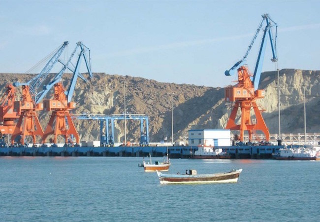
Pakistan has developed its second largest port Gwadar with the help of the Chinese along its Arabian Sea coast in the far southwestern corner of its Baluchistan Province. China-Pakistan-Economic-Corridor (CPEC) will stretch from the Western Chinese city of Kashgar in the Xinxiang province of China to the port of Gwadar, thus providing China an access to the Arabian Sea barely 600 kilometer east of the narrow Strait of Hormuz through which passes about 35% of the world’s oil shipments. CPEC which includes roads and railways will pass through the entire length of Pakistan, Azad Kashmir (PoK) and Baluchistan and it will reduce the distance for Chinese goods bound for Europe, Africa, the entire western hemisphere, substantially by almost 2000 miles and vice versa. Trade by CPEC will be bypassing the Strait of Malacca in Southeast Asia by that many miles. The Chinese goods if they were to be unloaded at New York or Norfolk and Baltimore rather than California will travel less by two thousand miles though the Suez Canal route (Downing, 3 May 2015).
Of course, undeniably, there are some other geo political considerations with multiple competing political interests relating to CPEP. All of those are fair when it comes to a nation state own’s interest and I am not blaming anyone.
About a 100 mile west of Gwadar, the Iranian port of Chahbahar was built by Pakistan’s archrival India to bypass Pakistan to reach its interests in Afghanistan in the early nineties. Despite US and EU pressure, India conducts a trade of about 15 billion dollars with the Islamic Republic and imports about 15 percent of its oil needs from Iran. India is the world’s fourth largest consumer of hydrocarbons. Before the recently negotiated nuclear deal India had openly declared that it would follow only the UN sanctions against the nuclear ambitions of Iran. Moreover, India is building a railway from Chahbahar to connect to the Iranian Railway System to reach the Central Asian markets and tap the mineral-rich Central Afghanistan (Singh, May 07, 2015).
Meanwhile, China has been increasing its presence in the Indian Ocean with its ‘String of Pearls’ with its presence to which it has recently been added the island nation of Seychelles. This term ‘Sting of pearls’ was coined by the United States, but it is frequently used by Indian defense analysts. The U.S. is courting India with the declared purpose of assigning the lead role in the Indian Ocean, which is unacceptable to both China and Pakistan. In fact, India’s cozying up to powers that China is suspicious of, compels China and Pakistan to strengthen their alliance further. China-Pakistan strategic naval partnership centered on Gwadar will scuttle the Indo-U.S. ambition of dominating the Indian Ocean.
For India, a major economic engagement between two of its adversaries – China and Pakistan – is a double dilemma. The economic reality of rising China compels India to support the various sections of road connectivity, like in Central Asia, East Asia and also connecting China with Myanmar, Bangladesh and India through the Southern Silk Road. Yet, India could not overcome its deep anathema towards Pakistan by objecting to the project, even though on the question of its passage through the disputed territory of Jammu and Kashmir, during Mr. Modi’s China visit in May. These Indian prejudices do not contribute to rapprochement between the two.
The Chinese economy is five times bigger than India’s. Even with higher growth rate this year, India will need more than 50 years to catch up. India needs to loosen up while coming to terms with China’s strategic rise and engage actively with China in OBOR. This will only help yield a more peaceful world. (Ashraf, 2015)
What this Corridor will offer: This economic corridor will also provide Pakistan with telecommunications and all the energy infrastructure facilities. It will improve brainpower sharing right between both of the countries. It will also transform Pakistan into that an enormous kind of regional economic hub. This investment will be a “game and fate changer” (Mag). It will also open trade routes for western china and access to Middle East region. With the completion of this project, we are much sure that no one will ever break the iron friendship of these two countries, Pakistan and China (EBRAHIM, 2016).
Implications
India with its zero-sum mindset is deeply concerned over the project. Any enhancement of Sino-Pak relationship could damage India’s aspirations to be the preeminent power in the South Asian and Indian Ocean regions. The Corridor running through the Karakoram affects India’s claims over the territories of the Pakistan-controlled Kashmir and the Northern Areas. Three parallel corridors will give strength in depth and Indian military concept of slicing through the country will become redundant. India’s policy makers are also worried about a possible two-front war in future. Any Indian protests are unlikely to yield anything. India may instead progress its own BCIM (Bangladesh, China, India and Myanmar) corridor at a faster pace to stay relevant. India should also try accelerating the Chabahar port project located 170 km west of Gwadar in Iran that was partially built by India in the 1990s. As China surmounts the need to go through Malacca strait and begins overlooking the strategic entry into the Indian Ocean, India has a geopolitical dilemma looking for answers and alliances (CHOPRA, Wed, 18 Nov 2015).
References
- Ashraf, S. (2015). CPEC. http://www.chinausfocus.com/finance-economy/the-china-pakistan-economic-corridor-indias-dual-dilemma/.
- CHOPRA, A. (Wed, 18 Nov 2015). Road to Gwadar: China’s global reach and its implications for India. dnaindia.
- Downing, B. B. (3 May 2015). The China-Pakistan trade corridor and its implications for regional security. The News Arab.
- EBRAHIM, Z. T. (2016, Feb 28). A boon for the economy, a bane for locals. p. 2.
- Express Tribune . (n.d.). Economic corridor: Pakistan, China agree on four-layer security.
- Mag, P. (n.d.). “China-Pakistan-Economic-Corridor-Route-Map”.
- Review, B. (2015). HEC.
- Sethi, M. (2014-15). What is CPEC (China Pakistan Economic Corridor) and how will it affect India, Pakistan & China? China: https://www.quora.com/What-is-CPEC-China-Pakistan-Economic-Corridor-and-how-will-it-affect-India-Pakistan-China.
- Singh, P. (May 07, 2015). The China Pakistan Economic Corridor and India. Institutes for Defence Study and Analysis .


